
Kordil Subbottom Processing
Kordil Subbottom Processing
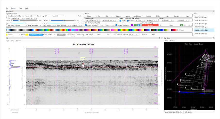
Kordil Subbottom Processing is an application for processing, visualising and interpreting sub-bottom profiler (SBP) data acquired during marine and nearshore geophysical surveys. Its signal processing tools support stratigraphic analysis, object detection and assessment of the seabed and underlying structures.
Tools developed around engineering, geophysical, UXO and geohazard survey workflows help take raw profiles through to interpreted project outputs. The software has been tested and validated for Innomar and EdgeTech sub-bottom profilers.
Processing and Interpretation Tools
- Band-pass and adaptive filtering.
- TVG and AGC gain control.
- Noise reduction and trace editing.
- Bottom tracking and seabed picking.
- Layer and horizon digitisation.
- Annotation and interpretation layers.
- Tide and draft offset corrections.
- Multi-layer interpretation for geology, objects and anomalies.
Synchronised Profile and Plan Views
The dual-view display combines high-resolution sub-bottom profiles with plan-view navigation. This helps relate interpreted layers and targets to their positions along the survey line. Adjustable gain and filtering tools improve signal clarity for interpretation.
File Formats and Outputs
| Supported formats | SEG, SEGY, SGY, DXF |
|---|---|
| Export formats | XYZ, CSV, KMZ, PNG, JPG, DXF |
| Profile outputs | Automatic segmented profiles and strip profile exports |
| Interpretation outputs | Point lists for digitised layers and marked targets |
Report-ready profile images and numerical outputs make it easier to transfer interpreted data into project reports and other engineering workflows.
Typical Applications
- Marine geophysical surveys.
- Offshore and nearshore engineering investigations.
- Pipeline and cable route surveys.
- Unexploded ordnance (UXO) and geohazard surveys.
- Port and harbour developments.
- Dredging and reclamation projects.
From Survey Data to Reporting
Open supported data and apply the required filtering, gain and offset corrections. Pick the seabed and interpretation horizons, mark targets and review the results alongside the plan view. Export profile images, layer points and target lists in the formats needed for the project.