Side Scan, Geomorphology & Seabed Clasification
Kordil utilizes side scan sonars for seabed classifications and geological morphology, detecting and locating artificial objects likely to exist on seabed. The content of research capability consists of but is not limited to:
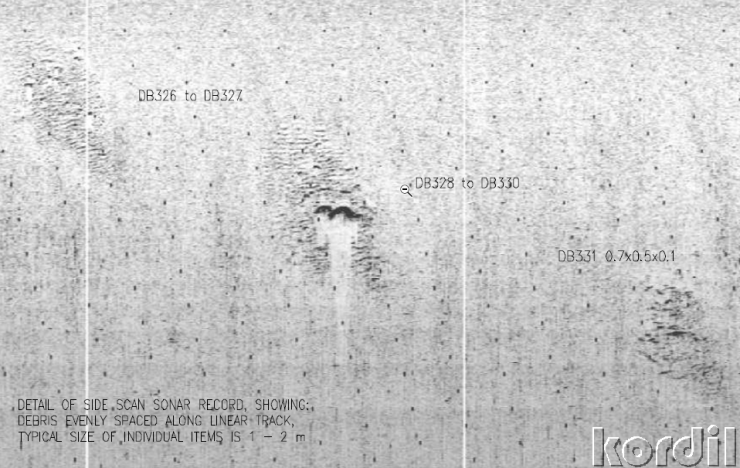
- Debris cleaning
- Geomorphology of seabed, riverbed, and lakebed
- Seabed classification
- Lost found
- Research for sunken objects
- Locating dangling objects (fishing nets or ropes)
- Obstacle detection for preventing navigation hazards which are not seen on bathymetry data
- Detection of live species existed on seabed or lakebed (seagrass, trees, wood, animals)
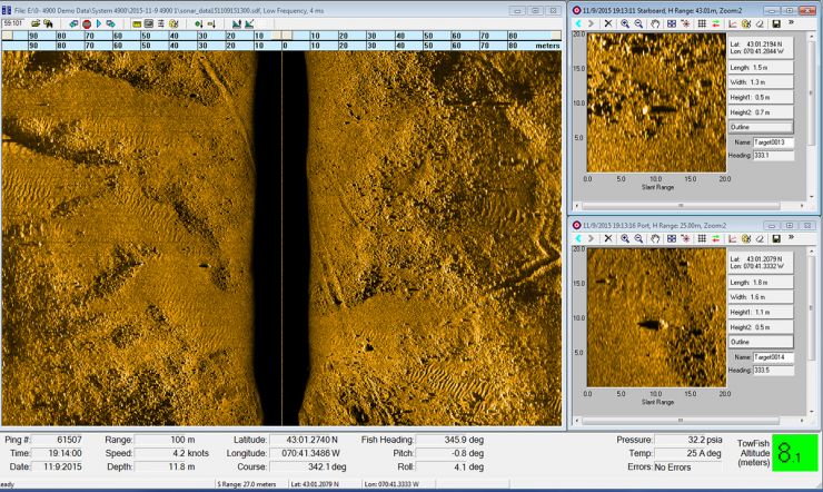
Seabed Classification & Geomorphology
For every geological survey, Kordil performs side scan sonar surveys over project area to define and locate seabed futures, dimensions, and boundaries that show different characteristics and have different boundaries. With seabed classification, sandy, rocky or muddy areas (or similar types) can be separated from each other.
Lost Search
Every year there are accidents happening at sea. Some of them really require research over a wide area due to the nature of accidents or incidents. Sometimes this also happens to have surveying equipment itself, and getting lost during underwater inspection. Kordil can assist you to locate those kinds of losses.
- Shipwrecks
- Airplane or helicopter search
- Sometimes search for lost person
- Search for flooded areas
- Search for fallen equipment at
Route Clearance Survey
Prior to commencing construction, an overall route inspection is required to make sure, during construction period no surprising objects leaning on seabed and creating serious obstacles for ships and crossing lines. This is usually done during engineering study but also recommended to do after heavy machinery traffic for construction over an area against unwanted drops or debris. This can be an anchor of a ship or a third party wreck which can cause technical and administrative issues. Having a clearance report of route is good to have.
Research for UXO
So many areas require research for unexploded ordnance (UXO) prior to commencing construction. This is essential because an area there was war likely to have some unexploded ordnance which is likely to explode during construction. This can cause serious accidents and reliability issues. To avoid such unwanted cases, UXO research shall be performed on whole lands that had wars nearly 100 years or more recently.
Navigation Safety - Locating Dangling Objects; fishing nets, ropes
To locate dangling objects such as fishing nets, ropes, and seabed futures, Kordil performs obstacle avoidance surveys for ships, tugboats and mariners. Especially channels, strikes, rivers and lakes can carry a lot of fishing nets which can cause serious mechanical issues on vessel's navigation.
There are potentially dangling objects which may not be reflected in bathymetry usually single beam bathymetry data, we always cover this with a side scan survey to make sure there are no unexpected spots in between runlines.
Find & Rescue; Diving support
There are several cases where there are drops at sea that require diving inspections. Kordil performs side scan surveys to reduce time of diving.