
Kordil Bathymetry Studio
The Complete Real-Time Navigation & Sensor Positioning Suite for Marine Survey
Kordil Bathymetry Studio (KBS) is a professional Windows application for hydrographic survey, dredging, and marine construction — built around one core idea: every position on and under the water, tracked, displayed, and logged in real time.
Whether you're steering a survey launch down runlines, tracking an ROV on a USBL feed, managing a multi-vessel dredge spread, or logging XYZ from a singlebeam echo sounder — KBS turns any NMEA-0183 position stream into actionable survey data.
Core Capabilities
1. Navigation & Dedicated Helmsman View
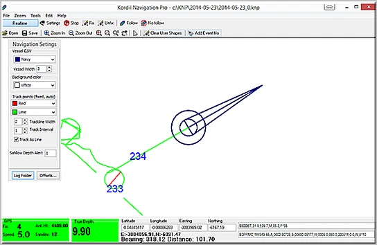
KBS's signature feature: a dedicated Helmsman window — a second, fully independent navigation canvas designed purely for steering.
- Head-up mode: the chart rotates around the vessel so the bow always points up the screen — steer by instinct, not by mental rotation. North-up mode available at a right-click.
- Motorway guidance: select a runline and KBS draws a steering corridor — parallel edge lines plus live KP markers that advance with the vessel, so the helmsman always knows exactly where they are along the line.
- Vessel-follow auto-centering, live speed readout, mirrored tracklines, independent zoom and pan — the surveyor works the main screen while the helmsman keeps their own clean view.
- Track the main vessel or any of the auxiliary vessels from the Helmsman window.
- Shallow-water alarm, cross-track awareness, and customizable vessel outline drawn to true scale.
2. Runline Generation & Precision Tracking
- Draw a route on the chart and auto-generate parallel or perpendicular runlines at any spacing and length.
- Live coverage swaths show surveyed ground as you go — no gaps, no double-sounding.
- Fixed and floating track lines with configurable width and spacing.
- Runline selection feeds directly into the Helmsman motorway — the guidance line is captured the moment you pick it and can't be disturbed by other on-screen selections.
3. USBL & Acoustic Position Tracking
Track underwater assets — ROVs, towfish, divers, AUVs — by feeding acoustic/USBL positioning output straight into KBS as a standard NMEA position stream on a dedicated serial channel. Each target appears on the chart as an independently shaped, colored, and named object, with its own coordinate log — perfect for laying cables, inspecting structures, or tracking towed sensors relative to the vessel.
4. Multi-Vessel Positioning
Track up to 4 vessels simultaneously on one screen: one primary plus three auxiliary receivers, each on its own COM port and baud rate. Per-vessel name, color, outline shape and dimensions, track recording, and individual coordinate files — a complete picture of your spread for dredging, tug-and-barge, or multi-boat survey operations.
5. Multi-Offset Sensor Positioning (Layback Engine)
The antenna is never where the sensor is. KBS's Vessel Geometry module defines unlimited sensor stations with precise forward/side offsets, then computes each sensor's true real-time position using live heading and vessel rotation.
- Per-sensor layback positions logged to dedicated
.SENfiles - NEW — Sensor GGA forwarding: stream computed sensor positions as standard NMEA GGA sentences via UDP or a selectable COM port (19200 baud default) — feed dredge computers, DP displays, or third-party acquisition systems directly
- Any sensor can be nominated as the active tracking reference
The Smart Choice for Singlebeam & NMEA Sensor XYZ Logging
KBS excels as an acquisition front-end: connect a GNSS receiver and a singlebeam echo sounder — or any NMEA-0183 sensor — and walk away with clean, time-stamped XYZ data. Depths are bound to corrected, projected coordinates and logged to CSV, sensor logs, and raw NMEA archives. If it outputs NMEA, KBS will position it, display it, and log it.
Full Feature Set
Positioning & Corrections
- NMEA-0183 engine parsing GGA, RMC, VTG, ZDA, GSA — serial or UDP input
- Built-in NTRIP client with RTCM decoding, caster profiles, mountpoint discovery, and serial output to the receiver — RTK without extra software
- Gyro/heading input, latency calibration, configurable read priority
Geodesy
- Transverse Mercator and Lambert Conformal Conic (1P/2P) projections
- Custom datums, user ellipsoids, full 7-parameter Helmert transformation to/from WGS-84
Data & Deliverables
- Export Google Earth KML/KMZ and AutoCAD R12 DXF
- Import KML/KMZ (with datum transformation), DXF 2018, XYZ/CSV point files
- Sound velocity profile (SVP) management with graphing; tide and draft offsets for post-processing
- Timestamped event logs, per-vessel coordinate CSVs, automated screenshot capture
- Depth labels, event markers, depth/speed overlay — fully configurable chart symbology
Usability
- Layered CAD-grade canvas with unlimited zoom
- Multi-language UI (English/Turkish) with built-in translation editor
- Themes, port monitor for raw NMEA diagnostics, virtual/high COM port support
- Runs offline on any Windows laptop, tablet, or wheelhouse PC — simple license registration, no dongle
Applications
Singlebeam bathymetry · Dredge monitoring & volume surveys · USBL/ROV/towfish tracking · Port, harbor & marina mapping · River & reservoir sounding · Cable & pipeline lay support · Multi-vessel construction spreads
Technical Specifications
| Item | Specification |
|---|---|
| Platform | Windows 10/11 |
| Position inputs | NMEA-0183 via serial or UDP — GGA, RMC, VTG, ZDA, GSA |
| Corrections | Integrated NTRIP client, RTCM, serial output to receiver |
| Tracked objects | 1 primary + 3 auxiliary channels (vessels, USBL targets, sensors) |
| Guidance | Dedicated Helmsman display, head-up/north-up, motorway corridor, KP markers |
| Sensor output | Layback positions forwarded as NMEA GGA — UDP or COM (default 19200) |
| Exchange | KML/KMZ, DXF R12 & 2018, XYZ/CSV/TXT |
| Geodesy | TM, LCC projections; custom datums; 7-param WGS-84 transformation |
| Logging | XYZ/CSV, .SEN sensor files, raw NMEA, event logs |
Kordil Bathymetry Studio — Track everything. Log everything. Deliver everything.
batimetristudio.com | © Kordil