Subbottom Survey
We are providing extremely accurate and reliable subbottom solutions that are used for engineering design, geological and geophysical investigations, volume computations, and asset management purposes. Kordil uses best in class surveying equipment that gives reliable solutions that are proven by many national and international clients. Kordil already performed sediment mapping for 24 dams and lakes in Turkey, and 3 lakes outside of country which were used for identification of sediment layers subject to rehabilitation.
Kordil also performed one of the longest seismic lines at Bursa coastal line which is 100 km long and is the longest seismic line ever performed using UHRS seismic system. Kordil deploys boomer, sparker, pingers, CHIRP with Full Spectrum Frequency Modulator systems depending on applications.
Subbottom Survey
Kordil performs geophysical surveys for engineering purposes prior to structural design, sediment analysis, dredging, and underwater installations using high resolution seismic instruments. The accuracy of information that we developed so far has been verified as tenth of borings and correlated with seismic data. Over the years gained experience in various fields and projects, and self confidence that we are able to provide reliable and accurate information from not only subsea, tenth of meters below the seabed using non destructive geophysical measurements.
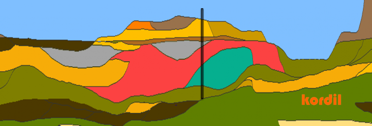
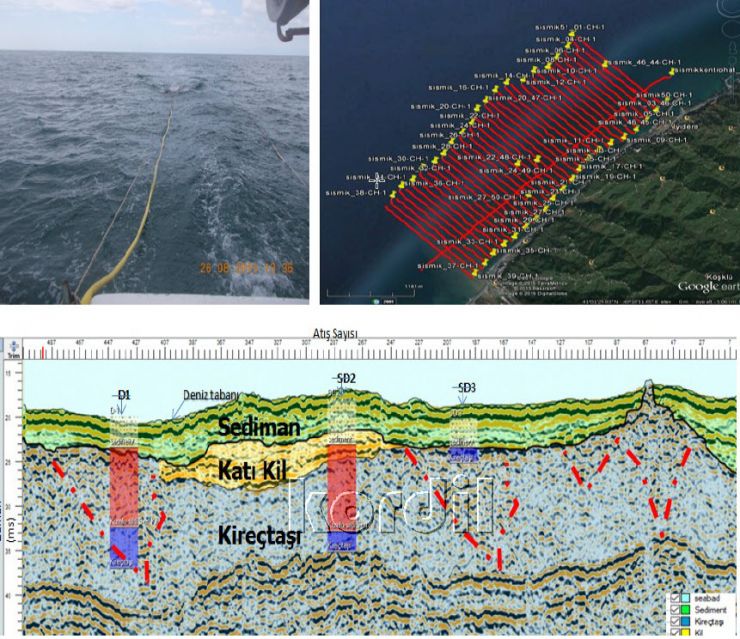
Kordil also over standardized presentation of geophysical data collected from subbottom, using best mapping and GIS capabilities and adopted them to presentation of geophysical data which was the weak point of geophysical companies. We do not give only an echogram, we give a full dataset of strata in 3D form, which can be used as real engineering data. There is an example profile given in the right image gallery.
Kordil also performed several projects for:
- Length of sheet piling to be driven
- Volume of seabed to be dredged with different dredgers
- Difficulty level of dredging
- Identification of buried structures or objects below the seabed
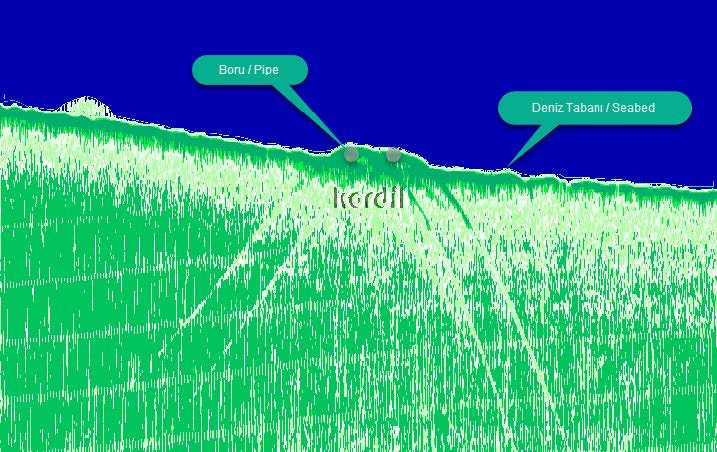
- Pipeline and cable line safety crossing
- Stability of seabed foundations
- Thickness of dirty mud to be cleaned and packed
- Thickness of sedimentation for life assessment
- Characteristics of strata layers
- Locations of geological borings as per layer boundaries
Route Surveys
We are providing service for cable and pipelines, defining seabed geology, defining existing crossing lines and debris, sediment transportation and geological mapping of pipeline routes as well as natural obstacles for best route planning.
Subbottom Survey for Ports & Harbours
Providing a 3D model of subbottom layers down to bedrock prior to engineering design for jetty structure, length of piles, location of bedrock, maximum depth of port, amount of dredging and life of sedimentation correlated boring samples.
We also perform subbottom exploration to eliminate geotechnical hazards likely to exist in the area.
Measurement of Sediment Thickness
Kordil has extensive experience in measuring sediment thickness of dams and river transports. We believe Kordil is the only experienced company that performed surveys over 25 lakes and dams. Also regularly following up sedimentation of a few hydropower projects, supported with bathymetry.
Sediment thickness once measured, future tracking can be tracked with changes in seabed, riverbed or lakebed elevations. So that reason, properly measuring of sediment thickness is very important for the future to have reliable data to asses life of a dam or a project.
We have several happy customers that rely on our data. One of the surveys we performed was verified by Client by making boring with a grid of 100 meters over 1200 hectares area that we covered, during winter over the frozen lake. The thickness of sediment we computed was perfectly matching with the boring data with some centimeter discrepancy (This project was for Alarko, name of the lake is Taldykol, Astana, Kazakhstan, references available upon request).
Geohazard Survey of Oil & Gas and Offshore Installations
Researching the presence of pressurized and explosive gases near boring locations before oil & gas rigs start drilling through. Kordil is capable of carrying out surveys at shallow waters starting near 150 meters down to shore, by utilizing several other surveying equipment together with UHRS and CHIRP subbottom profilers.
Kordil also provides services for breakwaters, barriers and similar heavy backfill areas for stability and engineering design. Prior to installing offshore platforms on the seabed, Kordil is capable of performing subbottom research against stability and settlement.