
Kordil GNSS-H4
Kordil GNSS-H4 GNSS Heading & Position with PC and Software
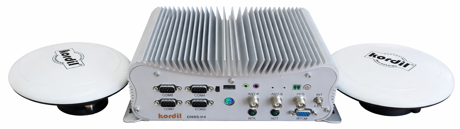
Kordil GNSS-H4: Integrated GNSS Position and Heading System
Kordil GNSS-H4 combines a dual-antenna GNSS receiver and an industrial computer in one integrated solution. It provides position, heading and timing information for marine surveys, hydrographic work and engineering applications. Kordil’s proprietary GNSS board supports multiple frequencies and satellite constellations, with Kordil Navigation Pro available as an optional software package.
The computer is an integral part of GNSS-H4. The system is not offered as a receiver-and-antennas-only package without the PC. The option without Navigation Pro still includes the integrated computer. NMEA outputs support integration with existing survey computers and data acquisition systems through suitable connections and software settings.
Applications
- Hydrographic and bathymetric surveys: Survey vessel position and heading information for integration with single-beam or multibeam data acquisition systems.
- Multibeam sonar time synchronisation: 1 Hz PPS and ZDA timing information for compatible equipment.
- Marine construction and positioning: Tracking workboats and platforms within project coordinates.
- Geophysical surveys: Referencing sonar, seismic and magnetic survey data to position information.
- Navigation and survey line guidance: Using position and heading data within Kordil Navigation Pro.
Position and Heading Accuracy
RTK positioning accuracy is specified as 20 mm + 2 ppm. This applies under appropriate RTK operating conditions with suitable RTCM corrections; it is not a standalone positioning specification. Satellite visibility, multipath, the correction connection and field conditions influence the result.
Heading accuracy is specified as 0.1° with 2 m antenna separation. Antenna spacing and installation geometry affect the heading solution. For separations such as 3–5 m, the installation layout, rigid mounting and antenna offsets should be assessed for the project. The 2 m specification should not be directly extrapolated into a guaranteed performance value at other separations.
Technical Specifications
| GNSS channels | 1226 |
|---|---|
| GPS | L1 C/A, L2C, L2P, L5 |
| GLONASS | L1 C/A, L1P, L2 C/A, L2P |
| BeiDou | B1, B3; global signals B1C, B2b |
| Galileo / QZSS | Galileo E1, E5a, E5b; QZSS L1, L2, L5 |
| RTK positioning accuracy | 20 mm + 2 ppm |
| Heading accuracy | 0.1° with 2 m antenna separation |
| Correction input | RTCM 3.x over serial, TCP/IP and NTRIP |
| NMEA messages | GGA, VTG, ZDA, HDT, GSA, GST |
| GGA / HDT output rate | Up to 10 Hz |
| Time synchronisation | 1 Hz PPS + ZDA |
| Serial connections | 6 COM ports; 4 × RS422/485 support |
| Ethernet / USB | 2 Ethernet, 4 USB 3.0, 2 USB 2.0 |
| Integrated computer | G8-1235U industrial fanless mini PC; Intel Core i7-1235U (supplier model designation), 32 GB DDR5 RAM, 128 GB NVMe SSD |
| Operating system | Windows 11 |
| Operating temperature | −40 °C to +75 °C |
| PC connectivity and power | Built-in Wi-Fi and Bluetooth module, dual wireless antennas; Huntkey 12 V / 5 A European-standard power adapter |
| Antenna cables | 10 m as standard; other lengths assessed on request |
| L-band / satellite-delivered PPP subscription | Not supported |
| Warranty | Typically 1 year; coverage and terms specified in the quotation |
Correction Data and System Integration
GNSS-H4 accepts RTCM 3.x corrections over serial, TCP/IP or NTRIP. A suitable external radio can provide corrections through the serial connection. NTRIP requires access to a correction service and a data connection. For offshore projects, communications coverage and the correction source should be planned before installation. The system does not support subscription-based satellite corrections or PPP services delivered over L-band.
GGA provides position, HDT provides heading relative to true north, and VTG provides course and speed over ground. GGA and HDT messages can be output at up to 10 Hz. PPS and ZDA are used for time alignment alongside the position data. Integration with an external computer or sonar system requires the message selection, port type, communication rate and timing settings to be configured together.
Package and Installation Options
Package with Navigation Pro: GNSS-H4 with its integrated computer, two antennas, standard antenna cables and Kordil Navigation Pro software. Package without Navigation Pro: The integrated computer remains part of the system, but the Navigation Pro licence is excluded. Current pricing, stock availability and delivery terms are confirmed at quotation stage for the selected scope and destination.
Antenna installation should account for sky visibility, antenna separation and offsets to the vessel’s reference points. Alternative lengths to the standard 10 m cables can be requested; cable type and suitable length are selected together for the installation. Published numerical specifications are not available for antenna and main-unit IP ratings, maximum cable length, or standalone/SBAS accuracy, so these requirements should be clarified before ordering.