
Marine Magnetics Synapse
Synapse Horizontal Transverse Gradiometer
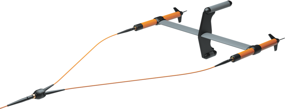
Marine Magnetics Synapse is a high-performance marine magnetometer and synchronized gradiometer array system designed for detecting, mapping and characterizing ferrous objects underwater. Its modular architecture allows a single sensor or an array of up to 30 synchronized nodes to be configured according to the required survey coverage and target size. The system is suitable for UXO investigation, pre-dredging clearance, cable and pipeline route surveys, archaeological investigations, wreck and debris mapping, and the detection of ferrous objects buried beneath the seabed or exposed on it. Each node can incorporate optional altitude, pressure-depth and inertial sensors, providing additional information for accurate positioning and interpretation of magnetic targets.
Features & Benefits
-
Rubidium Optically Pumped Sensor – Provides high sensitivity, low noise and reliable detection of small or deeply buried ferrous targets.
-
Synchronized Gradiometer Arrays – Multiple nodes are synchronized within microseconds, enabling accurate gradient measurements and simultaneous wide-area coverage.
-
Scalable up to 30 Nodes – The system can be configured as a single magnetometer, transverse gradiometer or larger multi-sensor array.
-
Sampling at up to 20 Hz – Delivers high-density magnetic data while permitting efficient survey speeds.
-
High Gradient Tolerance – Operates in magnetic gradients exceeding 10,000 nT/m, supporting surveys close to large ferrous targets.
-
Worldwide Operation – The sensor can be rotated to avoid its narrow dead zone and optimize performance for the local direction of the Earth’s magnetic field.
-
Neutral Buoyancy – Suitable for towfish operation, rigid array frames, side-scan sonar integration and AUV applications.
-
Integrated Survey Sensors – Optional altimeter, pressure-depth sensor and IMU provide altitude, depth and orientation information.
-
Flexible Communication – Supports FSK and RS-232 communication, with USB interfacing available through the deck equipment.
-
Automatic Array Management – Synapse Gen.2 automatically selects a master node, synchronizes the connected sensors and combines their readings into a single data stream.
-
Deep-Water Capability – Rated for operation to a depth of 1,000 metres.
Typical Uses
-
UXO Detection and Route Clearance – Detection and mapping of unexploded ordnance and other hazardous ferrous objects during pre-dredging, construction and offshore clearance surveys.
-
Cable and Pipeline Route Surveys – Identification of existing cables, pipelines, anchors, chains and other ferrous obstructions along proposed routes.
-
Wreck and Debris Mapping – Detection of shipwreck material, ballast, engines, structural steel and scattered metallic debris.
-
Archaeological Surveys – Location and mapping of buried or exposed ferrous archaeological remains.
-
Offshore Construction Support – Clearance surveys for dredging, piling, trenching, reclamation and marine infrastructure works.
-
Geological and Geophysical Surveys – Measurement of variations in the Earth’s magnetic field for geological interpretation and regional magnetic mapping.
-
Side-Scan Sonar and AUV Integration – Neutral-buoyancy construction and compact dimensions support integration with other marine survey platforms.
Key Specifications
|
Sensor type |
Scalar, rubidium optically pumped |
|
Operating range |
18,000 to 120,000 nT |
|
Sensor sensitivity |
0.01 nT, 10 pT/√Hz |
|
Resolution |
0.001 nT |
|
Sampling rate |
Up to 20 Hz |
|
Gradient tolerance |
Greater than 10,000 nT/m |
|
Operating zones |
Worldwide |
|
Dead zone |
One zone, approximately ±6° from the sensor centre axis |
|
Maximum array size |
Up to 30 synchronized nodes |
|
Synchronization |
Within microseconds |
|
Depth rating |
1,000 m |
|
Interfaces |
FSK and RS-232; USB through deck interface |
|
Standard supply voltage |
24 VDC |
|
Power consumption |
Approximately 4.5 W per node; 7 W with altimeter and IMU |
|
Towfish diameter |
76 mm |
|
Length |
Approximately 892 mm without altimeter; 940 mm with altimeter |
|
Weight in water |
Neutrally buoyant |
|
Optional sensors |
Altimeter, pressure-depth sensor and IMU |