Ping DSP
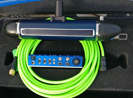
3DSS-iDX: Combined Side Scan and Multibeam System

3DSS-iDX: Combined Side Scan and Multibeam System
3DSS-DX combines multibeam bathymetry and sidescan sonar data into a single, streamlined system. Utilizing a patented signal processing methodology, it extends the conventional extends the single angle-of-arrival principle used in interferometric systems to accommodate multiple simultaneous backscatter arrivals. When combined with the 3DSS-iDX Multibeam Echo-Sounder Signal Processing Engine, the result is unsurpassed resolution and bathymetric accuracy over swath widths that can exceed 14 times water depth. Accurate, high resolution, ultra-wide swath echo-sounding and 3D/2D imagery, with integrated real-time surface sound velocity, high accuracy INS position / attitude and optional RTK, PPK, PPP provide the best available hydrographic survey and imaging performance in shallow water. The real-time 3D software enables accurate measurement of complex seabed and water-column features like pipelines, wrecks, cables, subsea structures hazards and habitats.
At the heart of the 3DSS-iDX sonar is Ping DSP’s state-of-the-art SoftSonar™ electronics technology with ultra-low noise, wide dynamic range receivers, state-of-the-art acoustic transducer arrays, Gigabit Ethernet, easy-to-use software interface, and integrated support for a wide range of third party survey software and hardware.
Technical Specifications
- Operating Frequency: 450 kHz
- Horizontal Beamwidth (2 way): 0.4°
- Vertical Beamwidth (selectable): 19°-125°
- Voltage Requirements: 12-28 VDC
- Operating Temperature: -5° - 45°
- Depth Rating: 10m
- Sonar Head Weight: 8.5 kg (in air), 5 kg (in water)
2D Sidescan (2D Imagery) Specifications
- Data output: Range and amplitude
- 2D imaging swath width: 10 to 20 times sonar altitude, varies with sound velocity profile, geometry and seabed type
- Max range: 200m per side
- Max range Resolution: 1.67cm
3D Sidescan (3D Imagery) Specifications
- Data output: Range, angle, and amplitude
- 3D Imaging swath width: 8 to 14 times sonar altitude, varies with sound velocity profile, geometry and seabed type
- Max 3D imaging range per side: 120m per side
- Max resolution: 1.67cm
Bathymetry Specifications
- Data output: Sounding range, angle, and amplitude
- Bathymetry swath width: 8 to 16 times sonar altitude, varies with sound velocity profile, geometry and seabed type
- Max bathymetry range: 120m per side
- Min. sounding depth: 0.5m
- Max. sounding depth: 75m (reduced swath width)
- Sounding accuracy: Exceeds IHO Special Order, meets or exceeds Dutch Norm 1A and Canadian Exclusive Order
- Multibeam Eq. mode settings: Beamwidth (0.25°-5°), Sector (90°-220°), Beams (3-1024), Mode (Equidistant, Equiangle, Hybrid)
- Legacy mode settings: Bin Count (3-1440), Bin Width (5cm – 200cm)
